

Walnut Canyon at Midday, Grand Canyon at Sunset
Without a concrete itinerary, I kept my eyes and mind open to possible hiking and photography opportunities. When I saw signs for Walnut Canyon National Monument near Flagstaff, I recalled all the times I told myself I would visit it the next time I was in the area, and this was that time.
The canyon itself isn’t particularly photogenic, nor were the ruins protected there, but it was nice to be out of the car and on a trail.
Heading north from Flagstaff, I stopped to photograph four white water towers tagged with “Love Life” grafitti in Gray Mountain, Arizona.

At the Little Colorado River Overlook, a daughter asked her father, “how was all this created?”
He said, “That depends on what you believe.”
“What do you mean?” she asked.
“The Bible says this was made by the Great Flood.”

The Desert View at the Grand Canyon was less crowded and more interesting than when Abby and I saw it in 2003. The watchtower is restored and looks great. I took advantage of my fisheye and made several images with it.


As I drove west along the rim, I heard an amateur radio operator in a glider over Prescott, Arizona, on the calling frequency, and gave him a signal report.


At the palatial new Grand Canyon South Rim Visitor Center, crowds were in the thousands. I thought to myself that people have no idea the kind of hell they create with tour busses.

I ended up at the Navajo Overlook for sunset which was not at all crowded. The light was stubborn until the moment of truth, sunset, when I got some very decent light.


Cottonwood Canyon Road, Zebra Slot, and Devil’s Garden
The Cottonwood Canyon Road from U. S. 89 in Arizona to State Highway 12 in Utah was rough and rutted from the wet winter, and took longer than I expected, though there were no technical or 4WD sections.

In Escalante, at the Bureau of Land Management’s expensive newish Grand Staircase/Escalante National Monument Visitor Center, I picked up a free permit to camp two nights in the Monument. Since there are no campgrounds (other than the always-full Lower Calf Creek Campground), car camping and backpacking is at-large. They tell you not to camp within 200 feet of water or a trail head, and don’t block the road, but otherwise camp wherever you want. They encourage you to stay where there are signs of previous camping.


The Hole-in-the-Rock Road, unlike Cottonwood Canyon, had been recently bladed, but had already begun to show moderate washboarding. I found that where possible, driving above 40MPH smoothed things out, a trick I’ve been using since dealing with the road to Chaco Canyon starting in 2000.
I was at the Zebra Slot Canyon trail head before midday. The trail is unmarked, but easy to follow. Rangers and the internet caution that it’s easy to get lost by accidentally following Harris Wash, but I found that part of the route obvious.
The Zebra Slot itself was one of my top tier items to see, and was everything I hoped and expected. from the mouth to the end is less than 200 yards, with just a couple of squeeze-through spots and no climbing. A couple of hikers had dropped their gear at the start of the narrowest part, but I needed what was in my pack, so I kept it with me, and it wasn’t much of a problem. The “Zebra” part at the very end is just 15 or 20 yards long.

While I was there I heard a voice say, “Come on. There’s a guy up ahead with a camera,” like he couldn’t believe I got my gear in there. I encouraged them to come the rest of the way, and they did. It was a friendly couple from San Francisco named Gray and Martha. I ran into them several more times during the afternoon and evening.
Back at the trail head I decided I had about enough time to hike around Devil’s Garden and photograph the beautiful Metate Arch as the sun went down. The sky remained hazy, but I feel like I made some decent images.
I set up my camp at a wide spot on the Harris Wash Road. I made Mountain Home brand rice pilaf, which was pretty good. I heated the water for it with my JetBoil stove. I nodded off several times in my camp chair, which was a great feeling. During my stay, no cars passed my location.


I slept in my car, which simplified camping considerably, since breaking camp consisted of folding up my camp chair. My sleeping bag, a mummy-style, made Saint Elmo’s Fire when I pushed it around or zipped it in the dark. The only problem with the sleeping arrangement was that my mummy bag is made of a very slick Nylon material, and tended to slide down toward the back of the car as I slept.
Dry Fork, Peek-a-Boo and Spooky in the Morning, Dance Hall Rock for Lunch, and Lower Calf Creek Falls in the Afternoon
The road to the Peek-a-Boo and Spooky slot canyons was the only questionable affair of the whole trip. A single-track road with a large gully on the left side (when driving in), it was marked with a “Four Wheel Drive Only” sign. The Rogue shook it off with no difficulty.
At the trail head I met a man named Chris who was hiking with his daughters Heather and Reagan, with whom I hiked for some of the morning. The trail led down a fairly steep canyon to a wash where we joined a wide-ish slot that took us west. GPS identified it as Dry Fork of Coyote Gulch. We hiked to a point where we ascended into the open desert, then back down.


Not far to the east was Peek-a-Boo. Web searches said there was a 12-foot wall to climb at the mouth of the canyon, which was correct, but which was cut with Moki steps, and was not difficult. By the time I reached the natural arches for which the canyon was named, we came across some shelves and overhangs that I was uncomfortable climbing because I was wearing my Keens (since I had been cautioned that some canyons might involve wet crossings), which have fairly poor tread on them, so I turned back.
Moving on to Spooky, I found the mouth of the canyon easily and entered to discover almost immediately why it is called Spooky: as you proceed, the canyon gets almost impassably narrow, and even though I don’t generally feel claustrophobic, I felt a very strong sensation of being trapped. I made my way some distance up the canyon until I felt I had experienced and photographed its character.


By the time I made it back to the trail head, it was lunch time, so I drove to Dance Hall Rock. After eating, I explored the area behind the signature piece to discover an enormous slab of sandstone slick rock, interrupted only by deep house-sized potholes. I climbed until I felt I was at the high point of the formation. The wind was furious, but it was well worth the effort.


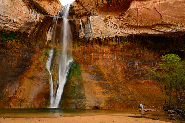
My last hike for the day was Lower Calf Creek Falls. I’d seen many nice images of it on the web, and Gray and Martha touted it, so I felt I shouldn’t miss it. The trail head is at the parking area of one of only two campgrounds in the Monument, which was quite crowded. The trail itself, three miles to the falls, is very easy (somewhat explaining its popularity), and not very interesting until you get to the actual waterfall. At 126 feet high, it’s quite impressive, but its stature is difficult to express visually unless you get a human figure in the frame, which I tried to do using another photographer who was working close to the water.
The water from the falls was pushed around by the wind, and frequently sprayed us.


It was evening by the time I was off the trail, so I drove back down to the Hole-in-the-Rock Road. I thought I might get the same spot I had the night before, but just a few hundred yards from the intersection with the highway I saw some campers in a pasture that had clearly been adopted as a de facto campground, so I pulled in there and found a nice spot near a big juniper.
A funny aside: my reading glasses hung from the collar of my t-shirt, and both nights camping in my car I forgot to remove them, so I slept with them there all night.
The Hogback, Zion Drive, Pipe Springs, Vermilion Cliffs, and Horseshoe Bend
I shot up Utah 12 to Boulder to see what caught my eye. I made some video with my Ion camera on its stick through the Rogue’s sunroof of The Hogback, a high, narrow strip of highway. After getting a coffee in Boulder, I did the same video in reverse.
I decided to drive through Zion National Park, since I had the time and a Park Pass. I did the same thing in the summer of 2008 and found it too crowded and hot, but hoped the early spring would relieve both. By the time I got to the visitor center, I began to think otherwise, though I was willing, as the signs and radio recommend, to park in Springdale and ride the shuttle into the park. Springdale held the answer: return in mid-winter or not at all. I drove all the way through town and never saw one empty parking spot.
When it came to the idea of driving through Zion National Park, I felt like Francis Coppola in Hearts of Darkness when he speaks of the “French plantation scene,” and says, “I was very unhappy on every count. The light, the whole thing. So everyone forget that we even shot it. No longer does it exist.”
With Zion behind me, I headed east along Arizona 389 to Pipe Springs National Monument, location of a water source used by settlers. The park itself wasn’t of much interest, but there was a short hike up the mesa above the park, so I took it and made a few images. Even when I have hiked all my planned trails, I still try to find hikes.
Continuing east, I discovered that the North Rim of the Grand Canyon was still closed for winter. Father along I joined U. S. 89a and followed it down the Kaibab Plateau to the Vermilion Cliffs. I stopped at a couple of locations and made pictures despite the hazy light, including the abandoned rock house in the town of Cliff Dwellers.

Since I decided to stay in Page, Arizona again, I thought I would visit Horseshoe Bend of the Colorado again, which I saw photographed in 2012. For reasons that were unclear, there were even more people at the site that three years ago; three or four hundred at least. Despite the crowds, I had fun making pictures of them and the Bend at sunset. Many of the other photographers (those with tripods and DSLRs like me) were making multi-frame high dynamic range exposures like I was. As in 2012, I got a fairly bland performance from the sky.


Navajo National Monument and the Road East

Up before dawn in Page, I got breakfast and headed east toward Navajo National Monument. I stopped to shoot the early light striking the Navajo Generating Station, then a handsome cluster of hoodoos farther along the road. GPS gave me some bad advice about how to get to the Monument, but after stopping to look at the map, I arrived by mid morning. It was sunny and very windy, and cooler than previous days. The long, ranger-guided trails were closed, but I took the three short ones and made a few telling images.


On Interstate 40 west of Albuquerque, I saw the sign for highway 6 and thought I would scout the same spot I saw 15 years ago, if only to make a photo of myself in the same spot. I don’t recall if I had to climb a fence (and trespass) to get to the edge of the canyon in 2000, but I did this time, without hesitation. The canyon and mountain beyond were just as beautiful as it was all those years ago.

- There is a scene from the movie Patton in which soldiers are arguing about where they are as they advance across France. One of them says, “This place isn’t even on the map!” “You know why? We’ve run clear off the map!” I thought of this as I drove farther than I had planned, to the point where I didn’t even have the right maps with me.
- I bought five cheap, cool stainless steel rings for myself at various locations in my travels. They replace the Moab ring that I broke last year.

- When I am on the road, I love the feeling of running on coffee. I get big cups of black coffee all day long.
- As I was discussing my plans, a coworker asked me, “What do you eat?!” I thought it was funny because when I am hiking and camping, everything tastes fine and nourishes me, no matter how primitive. I ate either MREs or commercial camp food from brands like Mountain House or Backpacker’s Pantry. The macaroni and cheese wasn’t very good, but the rice pilaf was nice. For meal or coffee/tea preparation, I boiled water using my JetBoil stove.
- Once again, a number of people asked me if I worked for the park service or BLM, and I kind of decided that it’s not only that I wear organic colors like green and tan, but also that I always have lots of stuff on my belt.
- A man approached after dinner in Albuquerque asking for money. Although he turned out to be harmless, I should have been more ready with my sidearm. “You have to decide to be aggressive enough soon enough.”
- Never miss an opportunity to buy ammo or gasoline, or to urinate.
Other Possible Names for this Trip…
- Dance Hall Days
- Natural Born Photographers
- Walking on the Sun
- Might as Well Be Walking on the Sun
- Olympia
- Triumph of the Will
- Lord of the Rings
- Three Ring Circus

Wow! Simply in awe. The photography is amazing! I’m definitely going to put this place on the bucket list. Beautiful… thanks for sharing!
Great post. Spectacular pictures, as usual.
One word comes to mind right now: Magnificent.
This could be my favorite all time post. ABSOLUTELY love it!
I really enjoyed the variety of terrain *and* people on this trip. To expand on my earlier comment on the trip video post: you really look in your element out there.
Really nice. You capture the Southwest well. I really like the photo of me with the “big camera” and the ground glass. Please email it to me.
Epic imagery and concise observation.
A note for those who think either is easy, try to hold your own with this standard. Richard’s passion and capture for beauty is won, through experience and faith in nature.
Richard!! Those shots were magnificent. Thanks to you I was able to see things I probably would have never seen before. The color you captured in the rocks and water falls were greater than words could ever express. Thanks!!