Circle of Dust, November 2009

The elegant stone masonry of the Pueblo Bonito great house is one of the reasons I find Chaco Canyon such a compelling travel destination.
LiveStong volunteers paint Stanley Marsh's Cadillac Ranch.
LiveStong volunteers paint Stanley Marsh’s Cadillac Ranch.

Driving to Albuquerque

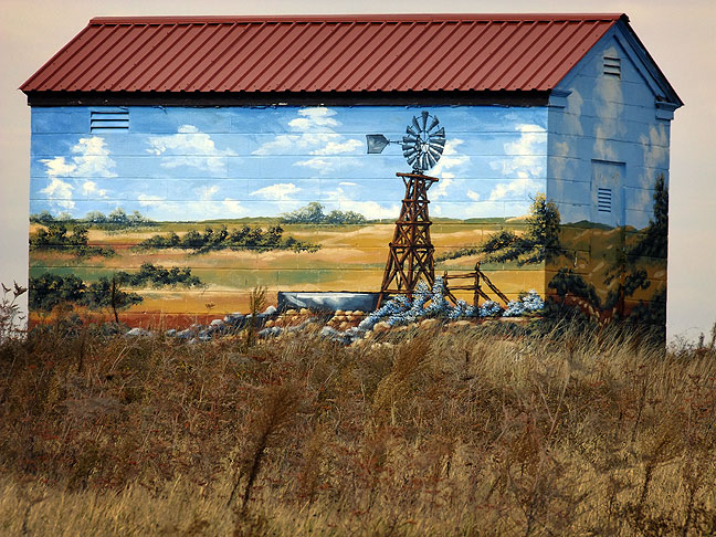
As always, the long ribbon of interstate 40 asphalt west proved an interesting drive. My first stop was at Amarillo, where I spotted the fact that the Cadillacs at Stanley Marsh’s Cadillac Ranch were yellow. I’ve stopped plenty of times at the Cadillac Ranch over the years, so I wasn’t planning to stop, but I’d never seen them yellow. Some volunteers from Lance Armstrong’s LiveStrong Foundation were painting them to raise cancer support. It made some neat images, and it was a unique opportunity. Also in Texas, I stopped to shoot a storage building that was painted with a farm scene, a sight I’d seen over and over, but only now stopped to photograph.

By the time I got to New Mexico, the light, which wanes quickly in November, was starting to fade. I wanted to photograph a particularly colorful rock outcropping on the north side of the highway, but I couldn’t remember exactly where it was, so I took a guess about which exit to take. I was right, and also ran into a very lovely abandoned church in Newkirk, New Mexico, which was soaking up some very nice late afternoon light. The outcropping didn’t work out the way I wanted it to because the access road is actually lower than the highway, so I didn’t really have a good shot at it. Next time.

Sunset on Interstate 40 near Clines Corners, New Mexico.
Volunteers from the LiveStrong Foundation paint the cars at the Cadillac Ranch yellow, LiveStrong's color.
Volunteers from the LiveStrong Foundation paint the cars at the Cadillac Ranch yellow, LiveStrong’s color.
Painted building, west Texas panhande
Abandoned church, Newkirk, New Mexico
Abandoned church, Newkirk, New Mexico.

U. S. 550, Pueblo Alto trail, Chaco Overlook trail

A café signs in Cuba, New Mexico stands in magnificent autumn sunshine.
The "crack" in the north rim of the canyon takes hikers to Pueblo Alto and New Alto
The “crack” in the north rim of the canyon takes hikers to Pueblo Alto and New Alto

I was up before dawn in Albuquerque, and on the road to Chaco Culture National Historical Park, one of my favorite places to camp and hike.

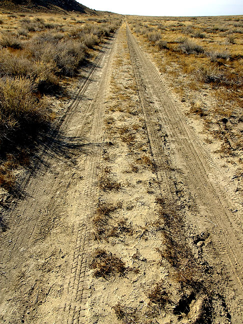
I saw dozens of interesting first-light possibilities, but just made mental notes about one day spending the day along this stretch of road, U. S. 550. I stopped a couple of times, but I think this stretch of desert deserves more time than I had.

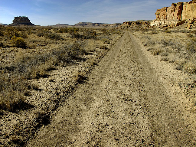
My destination was Chaco, which I hadn’t seen since 2003. I decided that I wanted to hike all the trails at Chaco, and when I arrived, I started with one of my favorites, the 5.6-mile Pueblo Alto trail. It leads up the north rim of Chaco Canyon to two great houses, Pueblo Alto and New Alto, and also leads to a short spur trail overlooking the largest Chacoan great house, Pueblo Bonito. On my hike, I didn’t see anyone else.

"The Crack" is a fissure in the northeast wall of Chaco Canyon through which the Pueblo Alto trail passes.
“The Crack” is a fissure in the northeast wall of Chaco Canyon through which the Pueblo Alto trail passes.
This view from near the top of "the crack" shows the Pueblo Alto trail, Chaco Wash, and the edge of the Kin Kletsin great house.
This view from near the top of “the crack” shows the Pueblo Alto trail, Chaco Wash, and the edge of the Kin Kletsin great house.
Mushroom rock is situated on the Pueblo Alto trail.
The Chacoan staircase would presumably be supplanted by wooden ladders.
This unique alcove of cracked boulders is situated on a spur trail about 300 yards off the Pueblo Alto trail.
The Chetro Ketl great house is visible from above along the Pueblo Alto trail.
This view shows a masonry doorway in the New Alto great house complex near the top of the trail. From New Alto and Pueblo Alto, hikers can see many miles of desert to the north.
This is the north face of Chaco Canyon from above.
A small opening in the stone stands vigil over Fajada Butte. Resting on the Menefee Formation, the layer near the top of the canyon is Cliff House sandstone.

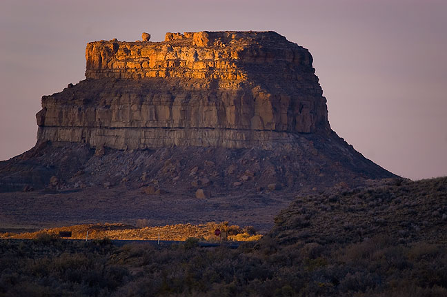
After setting up my camp site in the Gallo Campground and making a late lunch of vegetable soup and tortillas, I hiked the Chaco Canyon Overlook trail, which is full of interesting geology, some small natural arches, and an excellent view of Fajada Butte and Chacra Mesa. I saw another hiker, who was going back and forth. She told me it was her favorite trail in the park.

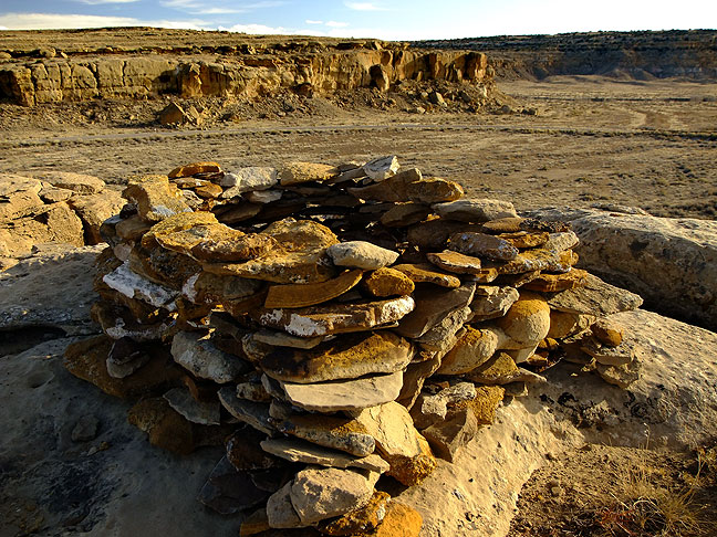
I also photographed a large trail cairn that sits right at the top of the switchbacks at the start of the trail. In 2003, it was U-shaped, but since then hikers have filled it in. The image I made of it six years ago was one of my favorites from that trip, and it was nice to see it again and photograph it again.

This trail cairn is near the start of the Chaco Overlook trail.
This view from the overlook trail shows the road to the Gallo Campground, the main road into the park, and Fajada Butte, one of the park's signature features. On this trip I learned that Fajada means "belt" or "banded."
This view from the overlook trail shows the road to the Gallo Campground, the main road into the park, and Fajada Butte, one of the park’s signature features. On this trip I learned that Fajada means “belt” or “banded.”
Alcove and small arches along the overlook trail.
Shelf rock and small opening; all of the arches at Chaco are too small to qualify as named natural arches.
Split boulders in evening light, common to the stone landscape of Chaco.
This alcove on the overlook switchbacks is full of cairn stones deposited by hikers.
A humorous trail cairn on the Chaco Overlook trail.
Last light at Fajada Butte, the signature formation at Chaco
Last light at Fajada Butte, the signature formation at Chaco.

It was dark by 5 pm, so I settled in for an evening in front of my camp fire. I brought several DuraFlame logs, since they are easy to light and last long. I also had my catalytic propane heater, which I put under my camp chair. By the time I was ready to sleep, it was quite cold, with a forecast low of 23.

This is my camp fire in a fire ring. On this visit it appeared that the fire pads and rings had very recently been replaced.
A nice star field is visible from Gallo Campground; the orange light on the cliff face is from my camp fire.
Fajada Butte shines at first light.
This is my shadow on the cliff wall at Gallo Campground at first light.

South Mesa, Wijiji, Pueblo Bonito

I photographed Fajada Butte at first light from the Gallo Campground. I also walked over to the Gallo Cliff Shelter and squeezed off a couple of frames.

Morning light streaming through doorway at Gallo Cliff Shelter, Gallo Campground
Morning light streaming through doorway at Gallo Cliff Shelter, Gallo Campground.
Your host poses in an eroded alcove on the switchbacks up the South Mesa trail.

My first trail was the South Mesa, which leads to a partially excavated Chacoan great house called Tsin Kletsin. The ruins are only mildly interesting, but the trail cuts through a very evocative swath of lonely, high-desert land. From the top of the mesa, you can see across the canyon to Pueblo Alto and New Alto.

As with most trails at Chaco in November, I didn’t see anyone else. It’s odd; though the trails are clearly marked and landmarks are always visible, I always feel lost at Chaco.

North-facing eroded alcove on the switchbacks on the South Mesa trail. I first hiked this trail in 2003. It leads up the south wall of Chaco Canyon, then crosses a lonely, intricate stretch of open mesa-top desert to the partially excavated Tsin Kletsin Chacoan ruins. The site is not particularly interesting, but this spare section of high desert is mysteriously compelling.
This is another view of the intricate sandstone erosions on the way up South Mesa.
There is only one tree along the South Mesa trail. I photograph this solitary landmark ever time I hike past it.
As the trail approaches the South Gap, the downclimb becomes more interesting, with jagged boulder fields and excellent views.
The descent into South Gap shows another erosion in the soft upper section of Cliff House sandstone.
This view looks farther down into South Gap. South Mesa is to the right.
The last part of the South Mesa trail follows this Park Service maintenance road
The last part of the South Mesa trail follows this Park Service maintenance road.
This smooth cliff is just below the rim as the South Mesa trail descends into the South Gap.

After an early lunch, I hiked the Wijiji Trail, the only trail on the east side of the park. It is another oddly lonely stretch. According to a park service person, the Navajo consider it evil for some reason.

This view looks west from Wijiji, with Fajada Butte on the left.
SCA ranger Lauren Blacik at the top of "Threatening Rock," the 30,000-ton boulder that collapsed on Pueblo Bonito in 1941.
SCA ranger Lauren Blacik at the top of “Threatening Rock,” the 30,000-ton boulder that collapsed on Pueblo Bonito in 1941.

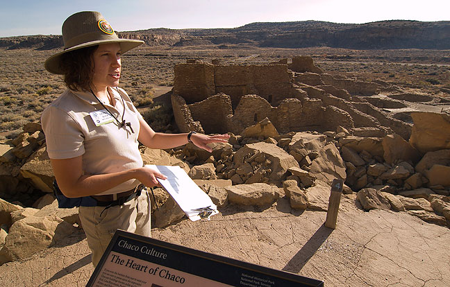
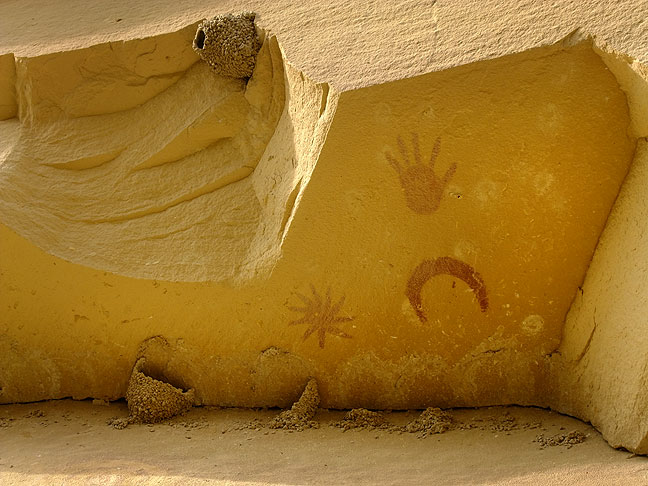
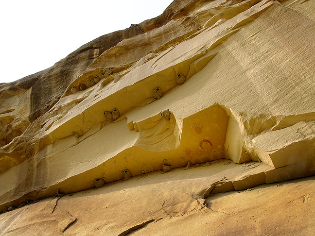
In the afternoon, I went to the visitor center, where I saw the girl who was hiking on the Chaco Overlook trail the day before; a volunteer ranger with the Student Conservation Association named Lauren Blacik, who invited me to take her tour of Pueblo Bonito at 2 pm. I took her up on it, and ended up enjoying it very much, and learning some things I didn’t know before. Lauren was enthusiastic and well-versed on the details of her tour. She had me take a picture of her with her camera for her family, explaining that she had been a ranger for one month.

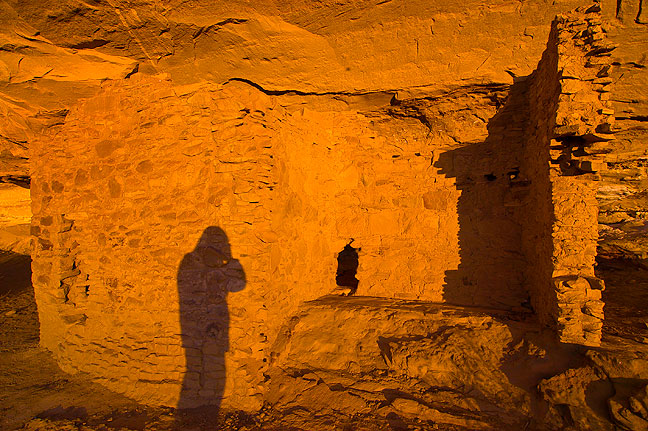
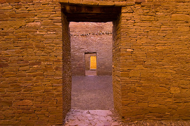
One of my goals in taking the tour was to find and photograph some of the impressive Chacoan stone masonry doors I have seen in so many photographer’s portfolios of Chaco.

I wanted to photograph them myself, and we found them and photographed them. I was very pleased with the result.

The aligned stone masonry doors at Pueblo Bonito are quite elegantly crafted.
This is a tighter view of the masonry doorways; by modern standards these doors are quite small, requiring even the smallest adult to duck and squeeze through.
Pueblo Bonito: intricate, ancient masonry doorways lit by soft, glowing light.
This view through a doorway shows a t-shaped entrance to a small room. The room inside was vandalized in 2004, and had to be completely restored by the park service.
This view through an interior window shows more windows and doors.
This is an exterior view of the Pueblo Bonito great house in warm afternoon light.

Back at the visitor center I overheard a woman asking if she could buy firewood anywhere, so I offered to give her a couple of my DuraFlame logs, since I had plenty.

Maria from Santa Fe at her Gallo camp site
Maria from Santa Fe at her Gallo camp site.

We struck up a conversation, and she told me that she was Maria, she lived in Santa Fe, and told me, “I’m just exploring. I haven’t been to Chaco in over 20 years.” She had a bike and was planning to ride all she could at Chaco. She also said she had just spent three nights at the De-Na-Zin Wilderness nearby. She wanted to give me $10 for the fire logs, but I would only take $5. The next morning I gave her two more logs, since I was done camping and she wasn’t.

Last light on the ruins at the Chetro Ketl great house, Chaco Canyon.
Cliff face near Chetro Ketl; on the left is a very large stone similar to "Threatening Rock," a piece that fell on a great house in 1941.
Cliff face near Chetro Ketl; on the left is a very large stone similar to “Threatening Rock,” a piece that fell on a great house in 1941.
This plaza view looks east with the Chaco Canyon wall in the distance.
The Una Vida great house, with Fajada Butte in the distance.
Looking southeast from Una Vida is this commanding cliff face above the visitor center.
The edge of a masonry wall at Una Vida great house, with Fajada Butte in waning light.

Dark brought another cold night in the Gallo Campground, and I decided it would be a good night, clear and still, to photograph the night sky. On the advice of a fellow outdoor photographer who makes a lot of star trace images, I decided to shoot a number of relatively short-exposure (30 seconds) images and stack them together in Photoshop, a technique that minimizes the noise associated with very long exposures with digital sensors. After some reading on the web, I was able to stack 60 images, resulting in a nice 30-minute star trace photo looking southwest.

30-minute star trace photo from my Gallo Campground camp site
30-minute star trace photo from my Gallo Campground camp site.
The cliff face near the end of the Peñasco Blanco trail shows the famous Supernova Platograph.

Peñasco Blanco, Angel Peak, Aztec Ruins, and Anasazi Arch

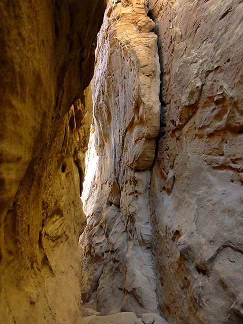
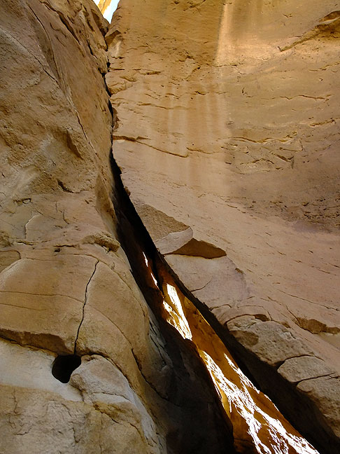
I broke camp early in Chaco, and hit the last trail in the park, Peñasco Blanco, which passes the famous Supernova platograph, thought to represent the supernova of 1054 AD. Again, I didn’t see anyone else on the trail. There are several great houses along this route, and some very interesting petroglyph panels along the trail. A long trail that crosses the Chaco wash near the west end of the park, this route affords views of its namesake, the Peñasco Blanco great house, for much of the way.

This view shows the cliff face where the Supernova Platograph is located.
Your host poses on the Penasco Blanco trail.

With all the trails at Chaco under my belt, I drove north to U. S. 550, then headed northwest to spend the night in Farmington, New Mexico.

Along the way I stopped briefly at Angel Peak, which we visited in 2003, to see if anything had changed. The site was essentially unchanged, with just a few more gas and oil wells visible. It has been renamed, however; it is now the Angel Peak Scenic Area; six years ago it was the Angel Peak National Recreation Area.

Angel Peak Scenic Area, New Mexico

I made a few passable frames, but since I wasn’t hiking, and had gotten lots of really great stuff in 2003, I decided to drive on.

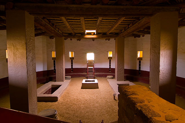
My next stop was Aztec Ruins National Monument, where I wanted to rephotograph the reconstructed Great Kiva. I was always disappointed in my result six years ago, and wanted to try again. I thought I knew how I wanted to reshoot it, and shot it that way, but also made a fisheye view, and that ended up being my favorite.

This is the Great Kiva at Aztec Ruins National Monument, New Mexico.
View of the inside of the reconstructed Great Kiva at Aztec Ruins made with 10-17mm fisheye lens
View of the inside of the reconstructed Great Kiva at Aztec Ruins made with 10-17mm fisheye lens.

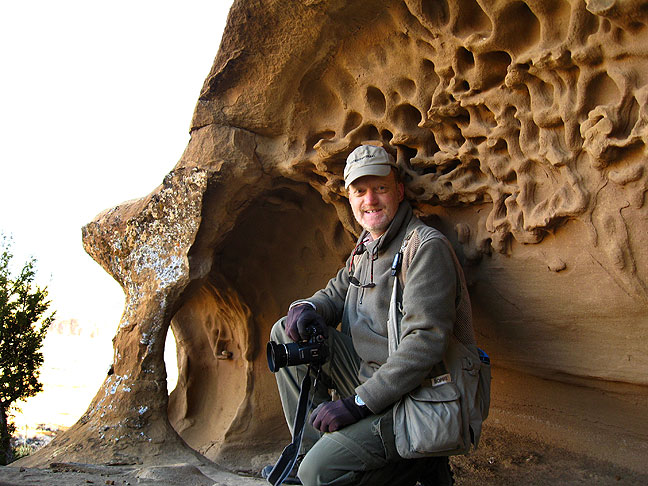
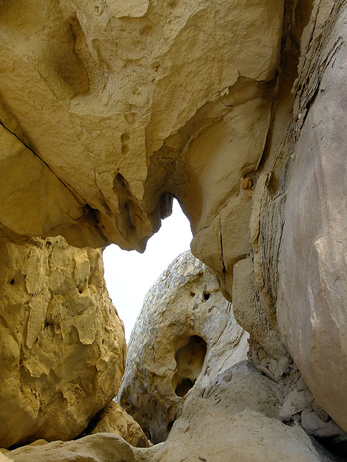
My next stop was just up the road from Aztec. The rangers at Aztec gave me a map of local arches, and I wanted to find and photograph the largest of them, Anasazi Arch.

Anasazi Arch, also known as Cox Canyon Arch, north of Aztec, New Mexico
Anasazi Arch, also known as Cox Canyon Arch, north of Aztec, New Mexico.

The brochure had GPS coordinates, so I plugged them in, and my GPS got me close enough that I could figure out the rest. Getting to the arch after parking involved a bit of cliff scrambling, and some route finding, but in the end wasn’t overly difficult. Among other things, I could hear the hum from the oil rig pumping station below, so I could always follow the sound if I felt lost. It was obvious from the beer cans and tire tracks in the area that it was a party hangout at night. The arch itself is impressively big and beautiful.

This formation is just a few steps away from Anasazi Arch in far northern New Mexico.

Finally, I settled in to a motel room in Farmington for the night.

Bisti Wilderness, El Morro, and driving to Tucumcari

One item I wanted to be sure to see and photograph on this trip was the Bisti Wilderness Area, about 35 miles south of Farmington, New Mexico. Aside a short day hike in 2001, I haven’t seen enough of this huge, alien landscape.

In 2001, we hiked east and then north into an interesting area of eroded towers and washes, but I wanted to see something different this time, so I struck out directly east, then bent southeast as I followed the Bisti Wash. I came across some very interesting fields of hoodoos, as well as some excellent eroded bentonite hills. Despite the fact that the light was stubbornly subdued by a veil of high clouds, I felt I was still able to shoot some very interesting stuff.

A small sticker makes a statement on the trail head sign at Bisti.
Bisti photographers Chris and Steve pose for me in the heart of the Bisti Wilderness.

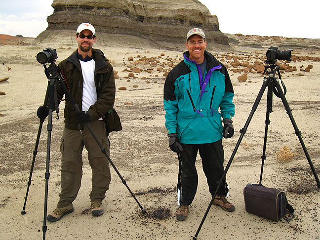
While I was exploring, I topped a red hill to sort out where I wanted to go, and spotted a tent and two figures who appeared to be people taking pictures. I made my way that direction, and approached and asked, “I’m looking for a formation called the ‘Cracked Eggs.’ Do you know where I could find it?”

Steve and Chris made this image of me as I spotted them in the distance.

“It’s right here!” they explained. We talked for a while, and they told me they were Steve and Chris from Albuquerque, and that they had come just for a couple of days to make a few pictures. The night before, they made some light-painting photos of the Cracked Eggs while they camped.

With light subdued by clouds and blowing dust, I chose to shoot the "Cracked Eggs" at the Bisti in black-and-white.
With light subdued by clouds and blowing dust, I chose to shoot the “Cracked Eggs” at the Bisti in black-and-white.


A hoodoo in a slanted section of erosions at Bisti.
A thin shelf of rock; it's hard to imagine this will still be standing in five years.
A thin shelf of rock; it’s hard to imagine this will still be standing in five years.
This bird-like hoodoo stood alone in an open, flat area.
This small window is too small to be classified as a natural arch.
With a narrow neck and darker capstone, this one seems to reach for the sky.

Since the light wasn’t cooperating, I decided to hike out around mid-day. I looked at a map for something that might be an interesting afternoon stop, and saw El Morro National Monument to the south. In 2000, I tried to visit it, but was too late in the day, so it was closed. This time, however, I would be there right after lunch, and I would be able to hike any short trails they offered.

El Morro National Monument marks a stopping place on routes west because of it's year-round water source.
El Morro National Monument marks a stopping place on routes west because of it’s year-round water source.
Woodpecker rock is a large natural arch that look like it could fall any day.

I was surprised and delighted by the one trail, the Headland Trail, at El Morro.

It leads first past the reason for its significance, a large pool of water that stays full all year, which many years ago allowed travelers to stop and fill up on their journeys to explore the west. One result of this was “Inscription Rock,” the next item on the trail, which shows hundreds of historical messages carved into the stone. The trail continues up and around these amazingly beautiful sandstone towers past a large, oddly-structured natural arch called “Woodpecker Rock”, and leads around a spectacular box canyon, then past a Mogollon ruin. I was surprised that all this was hidden here, and glad I came.

This view shows the approach to the rim trail at El Morro National Monument.
Climbing to the top of the rim above the box canyon at El Morro yields this rewarding view.

The Drive Home

The drive home from Tucumcari is usually fairly uneventful, but on this occasion, I wanted to give another look to the Cadillac Ranch, to see if the yellow they had painted five days earlier was still there. Sure enough, the graffiti, part of the life of the Cadillac Ranch, had come back. It was pretty amazing, actually.

The Cadillac Ranch as it appeared on Sunday (left), and Fiday, five days later (right)
The Cadillac Ranch as it appeared on Sunday (left), and Friday, five days later (right).

It was another excellent excursion out west, and from the moment it was over, I was planning the next one.

Self portrait on the road, somewhere in New Mexico
Self portrait on the road, somewhere in New Mexico.
Evening sky at Fajada Butte, Chaco Canyon.

1 Comment

  1. Thanks for allowing me the pleasure of your pictures. I was able to dream about being there. I would love to see these places in person but with my health it is highly doubtful that I will ever be able to. I love your attention to details. The small things ended up grabbing most of my attention. Thank you again for taking me on your journey.

Leave a Reply

Your email address will not be published. Required fields are marked *

This site uses Akismet to reduce spam. Learn how your comment data is processed.